 Safe Road
Safer trips. Better fleet control.
Safe Road helps drivers plan routes, assess road quality, and get trip analytics — while giving businesses more control over how their vehicles are used.
- Real-time navigation
- Road quality rating
- Trip analytics
Why Safe Road
One app for drivers and business
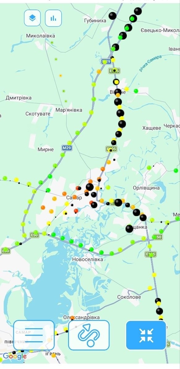
Navigation & routes
Route planning that accounts for the actual road the driver will take.
Road quality rating
Insight into road surface condition along the trip route.
Trip analytics
Structured data for every trip: route, time, speed, distance, and body vibration data that helps assess suspension condition and road surface quality.
Multiple devices
Connect the app for every driver and scale together with your fleet.
The problem
Driving a car, you see the road. Running a fleet, you need data.
Fleet businesses face challenges that aren't visible from the driver's seat.
Not enough trip information
Companies don't always know which routes their drivers actually take.
Road quality varies
The same route can have sections in completely different condition.
Trips are hard to analyze
Without structured statistics, it's hard to evaluate routes and trips.
A vehicle is a cost
Poor roads, extra kilometers, inefficient routes, and aggressive driving accelerate vehicle wear and increase operating costs.
The solution
Safe Road turns trip data into useful information
The same route, now with navigation, road rating, and analytics — for the driver and for the business.
Problem
Driver doesn't know road conditions ahead
Result
Routes with road surface quality rating
Problem
Company can't see actual routes driven
Result
Trip history with details for every route
Problem
No unified view across the fleet
Result
Speed, time, and distance stats for every trip
Problem
Hard to evaluate trip efficiency
Result
Structured analytics for informed decisions
Problem
Company can't see how drivers treat the vehicle
Result
Body vibration and harsh-maneuver data for monitoring driving style
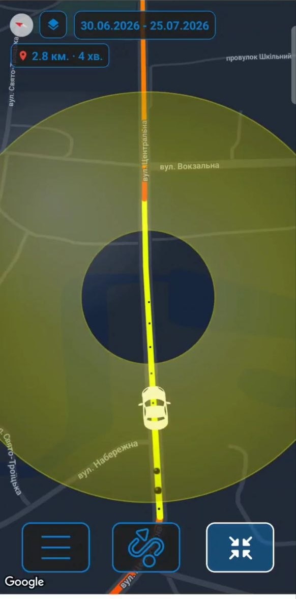
Navigation that accounts for the real road
Safe Road helps drivers plan a route and get additional road information during the trip — not just where to go, but what to expect along the way.
Route planning
Building a route to the destination.
Speed
Current speed and limits on the road section.
Distance & time
Distance to destination and estimated travel time.
Road sections
Information about the condition of road sections on the route.
Easy navigation
A clear interface for use while driving.
Know not just where to go, but what the road will be like
Safe Road rates road surface condition based on the vehicle's body vibration while driving. Drivers prepare better for a trip, and businesses get insight into both routes and the technical condition of their fleet.
- Good section
- Medium quality
- Poor section
The rating is based on data collected during trips.
The same vibration data is also an indirect signal about suspension condition: sudden spikes can mean a poor road, or worn suspension parts worth checking.
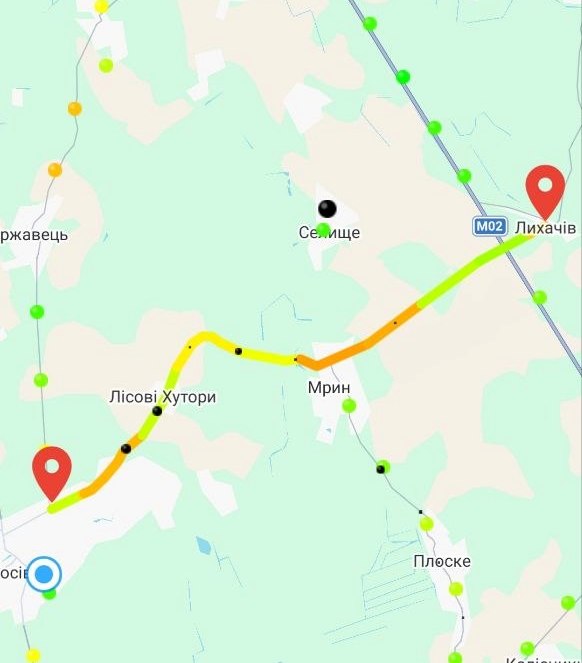
The trip is over. The data remains.
Safe Road helps turn everyday trips into structured data for analysis — route history, duration, speed, distance, and body vibration data that helps monitor driving style and suspension condition.
Every trip becomes a record: route, time, speed, distance, plus average and maximum body vibration.
Trip history
A list of every trip with route details.
Distance
Distance covered on each trip.
Duration
Time on the road for each route.
Speed
Speed data throughout the trip.
Body vibration
Average and maximum vibration per trip — for assessing suspension condition and road quality.

Know where the car is before you even call the driver
Drop a point on the map and Safe Road will message you in Telegram the moment a vehicle gets within 100 m, 1 km, or 5 km of it — or moves away from it. Works for any driver's device, no phone calls needed.
Flexible radius
100 m, 1 km, or 5 km — choose exactly how close counts as close enough.
Instant Telegram alerts
Notifications land straight in Telegram — no calls to the driver, no back-and-forth.
Any device
Set up a separate geofence rule for every vehicle in the fleet.
3 devices free
Try it free on up to 3 devices, or connect 4 or more on a paid plan.

For business
What does the business get?
Control
More information about the company's trips, routes, and how vehicles are driven.
Analytics
Data you can use to analyze how vehicles are used.
Safety
More information for the driver on the road, and for the business — signals about aggressive driving that puts cargo, passengers, and the vehicle itself at risk.
Driving style
Body vibration and harsh-maneuver data help spot aggressive handling of company vehicles early.
Efficiency
Better understanding of routes and vehicle usage.
Scalability
Connect more devices as your business grows.
Who it's for
Safe Road for different types of business
The product is useful for any business where a vehicle is a working tool.
Carriers
Route and road condition control for freight and passenger transport.
Logistics companies
Trip analytics for evaluating delivery routes.
Delivery services
Navigation and trip history for couriers and delivery drivers.
Service companies
Control over vehicle trips to clients and job sites.
Fleet businesses
A unified view of how all company vehicles are used.
Sole proprietors with multiple vehicles
Simple trip analytics without complex management systems.
How it works
From setup to scale
Install Safe Road
Download the app on the driver's device.
Plan a route
Use Safe Road during trips.
Get the data
Review trip history and statistics.
Scale up
Connect more devices as your business grows.
Pricing
Choose a plan for your business
Transparent pricing based on the number of devices in your fleet.
Up to 3 devices — free, starting today
Download Safe Road and connect up to 3 devices — free, with no time limit. Try navigation, road quality rating, and trip analytics before choosing a plan for your business.
For a small fleet
Safe Road Basic Monthly
4–10 devices
A starting plan for small teams beginning with navigation and trip analytics.
- Navigation for every driver
- Road quality rating
- Trip history
- Basic route analytics
- Telegram alerts on vehicle location (100 m / 1 km / 5 km)
- Rules can run for up to 30 days
For an active fleet
Safe Road Plus Monthly
11–50 devices
The optimal plan for mid-sized fleets that need full analytics.
- Everything in Basic
- Advanced trip analytics
- Driving style and body-load monitoring
- Fleet-wide statistics
- Priority support
For large fleets
Safe Road Pro Monthly
50+ devices
A solution for large companies and carriers with a large-scale fleet.
- Everything in Plus
- Unlimited device connections
- Dedicated account manager
- Custom partnership terms
Ready to bring Safe Road to your business?
Connect Safe Road for your drivers and get more insight into every trip, starting today.